Očhéthi Šakówiŋ Lakota Land Loss, 1851–Present
A Note on Maps, Boundaries, and Spatial Epistemology
Boundary lines on maps are legal fictions — spatial projections of political agreements and legislative acts onto a surface that cannot represent the contested, contingent, and often violent processes that produced them. The Fort Laramie Treaties rendered here as polygon edges were not consensual descriptions of territory; they were instruments produced through negotiation, duress, and subsequent violation.
Lakota spatial epistemology was not bounded in the sense these maps imply. The Očhéthi Šakówiŋ understood territorial relationships as relational and reciprocal — organized around movement, kinship, seasonal use, and cosmological orientation — not as exclusive sovereign enclosures. The concept of territory as a bounded, transferable, quantifiable space belongs to European legal traditions exported through the treaty system, not to how Lakota peoples understood their relationship to the Earth.
There are no Lakota-authored maps in this dataset. This absence is not incidental. Lakota spatial knowledge was transmitted through oral tradition, ceremonial practice, and waníyetu wówapi (winter counts) — forms that encoded place, event, and relationship, but not the fixed two-dimensional representations that enter archives and become GIS data. Absence from the archive is not absence of knowledge. This project can only map what the United States claimed, ceded, allotted, and transferred. That is not the same thing as Lakota territory. The asymmetry should accompany every reading of these maps.
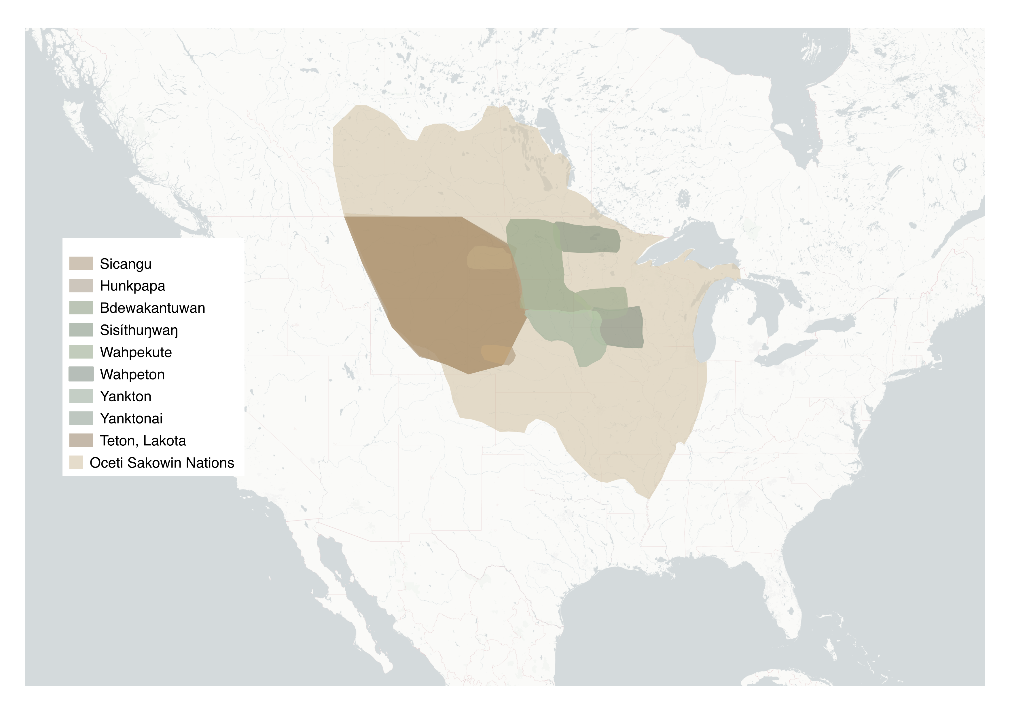
The Očhéthi Šakówiŋ, Before 1851
The territory of the Očhéthi Šakówiŋ (the Seven Council Fires, the confederacy the United States would call the Sioux) extended across the Northern Great Plains from the Missouri River west to the Rocky Mountain foothills, and from the Platte River north into present-day Canada. At its heart stood the Black Hills: Pahá Sápa, the center of the Lakota world. The confederacy comprised seven distinct nations — the four Dakota, the two Nakota, and the Teton Lakota — whose relationship to this land was collective, relational, and non-commodified. No document bounded it.
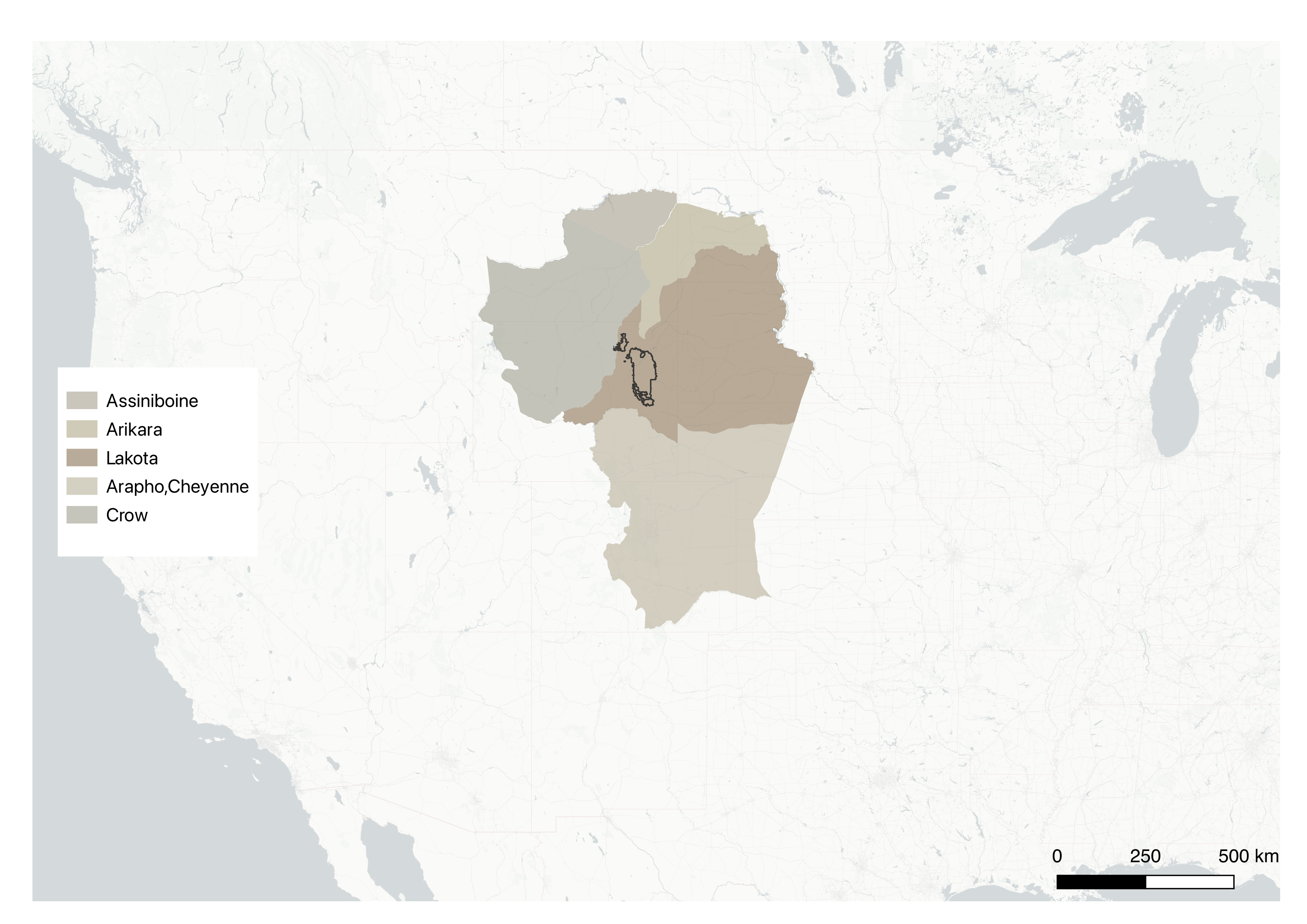
The 1851 Fort Laramie Treaty
The first Fort Laramie Treaty of 1851 — the Horse Creek Treaty — formalized territorial boundaries between the United States and the nations of the Plains, recognizing a Lakota homeland of more than 60 million acres centered on the Black Hills, spanning present-day North Dakota, South Dakota, Montana, Wyoming, and Nebraska. The promise was made on paper, in a hand, to specific people, in a specific place: the De Smet map of 1851, drawn by Jesuit missionary Pierre-Jean De Smet at the council's conclusion, is the surviving cartographic record of that agreement. The treaty was not ratified as agreed; the Senate unilaterally reduced the annuity period from fifty to ten years without returning the change to the original signatories (Deloria and DeMallie 1999).
Historic map: De Smet map, 1851. Drawn by Jesuit missionary Pierre-Jean De Smet at the conclusion of the Horse Creek Treaty council — the only surviving cartographic record of the territorial promise made that day. Library of Congress, Geography and Map Division.

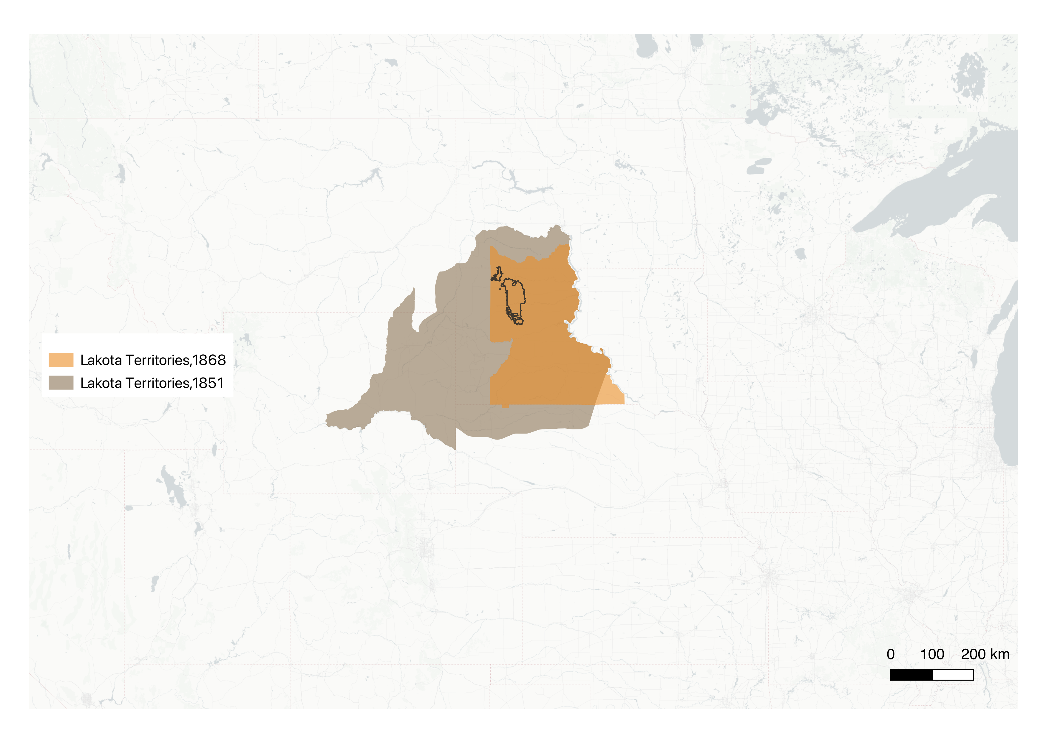
The 1868 Fort Laramie Treaty
The 1868 Fort Laramie Treaty was more significant. Signed after Lakota forces under Red Cloud successfully closed the Bozeman Trail and forced the abandonment of US Army forts, it established the Great Sioux Reservation — guaranteeing the Lakota permanent possession of all land west of the Missouri River in present-day South Dakota, including the Black Hills. Article XII was explicit: no future cession would be valid without the consent of three-quarters of all adult male Lakota. The United States had, in its own legally binding terms, acknowledged Lakota sovereignty over Pahá Sápa. Six years later, gold was discovered there (Ostler 2004).
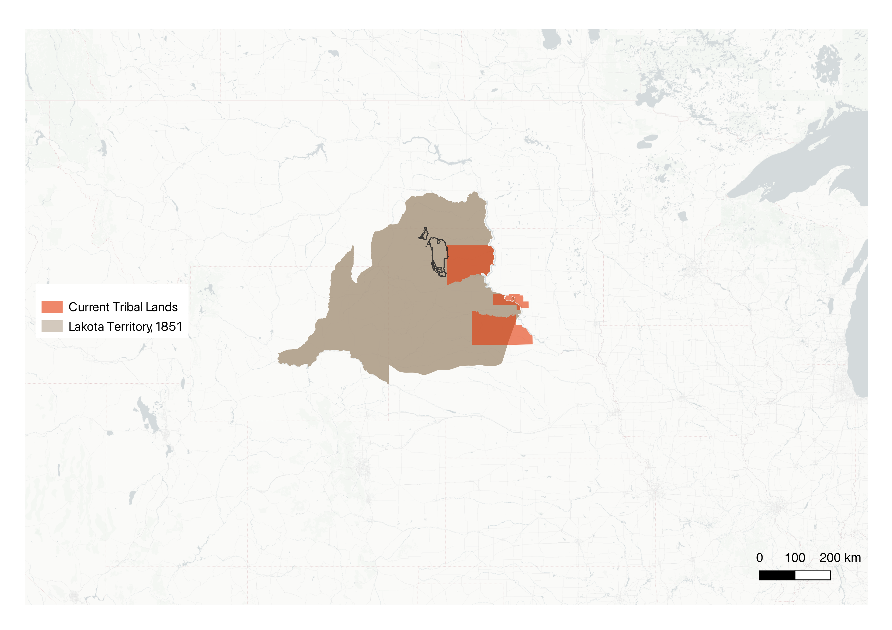
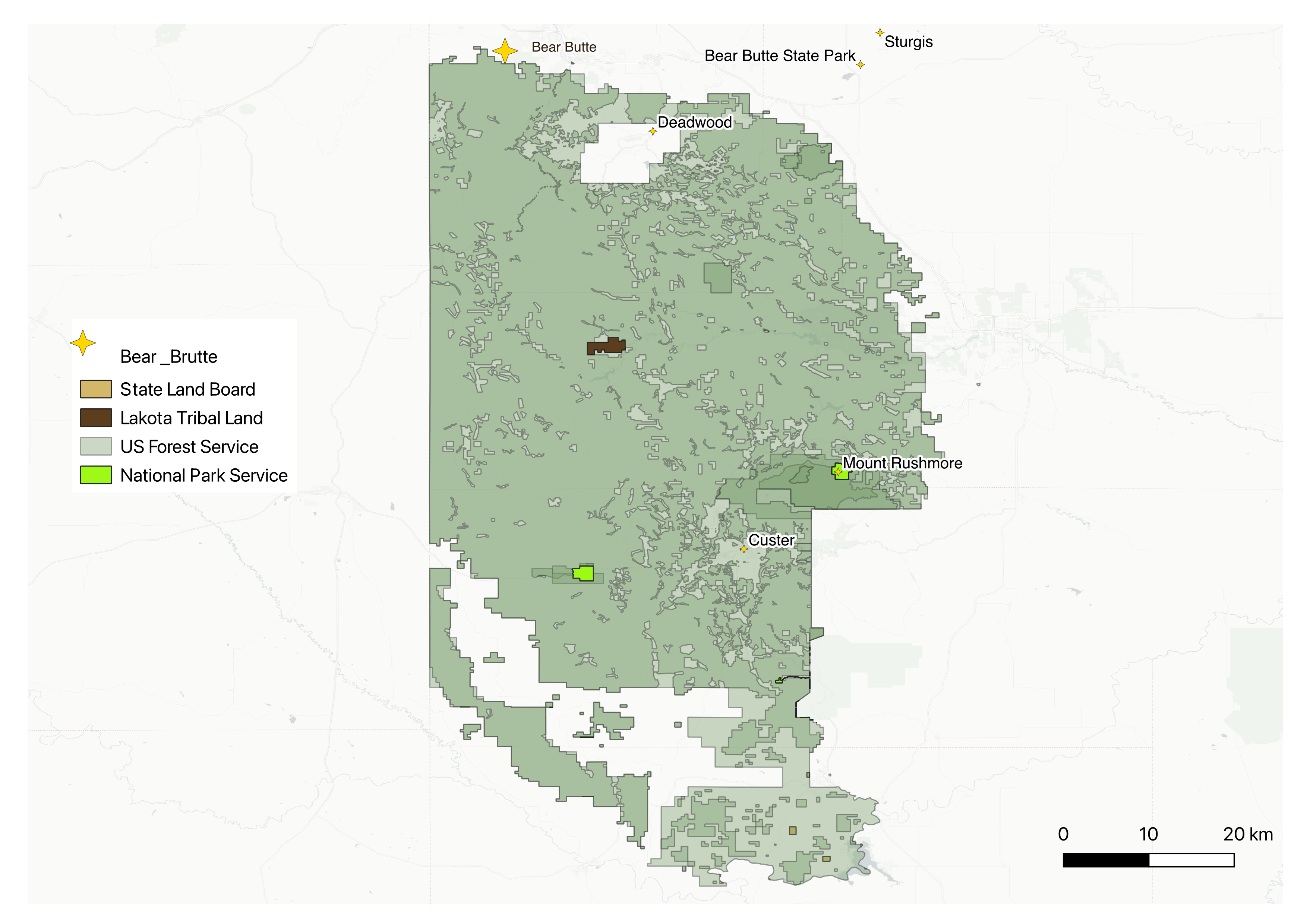
In each map below, the Black Hills / Pahá Sápa are outlined in black. These are the heart of the Lakota world and anchors these changing boundaries.
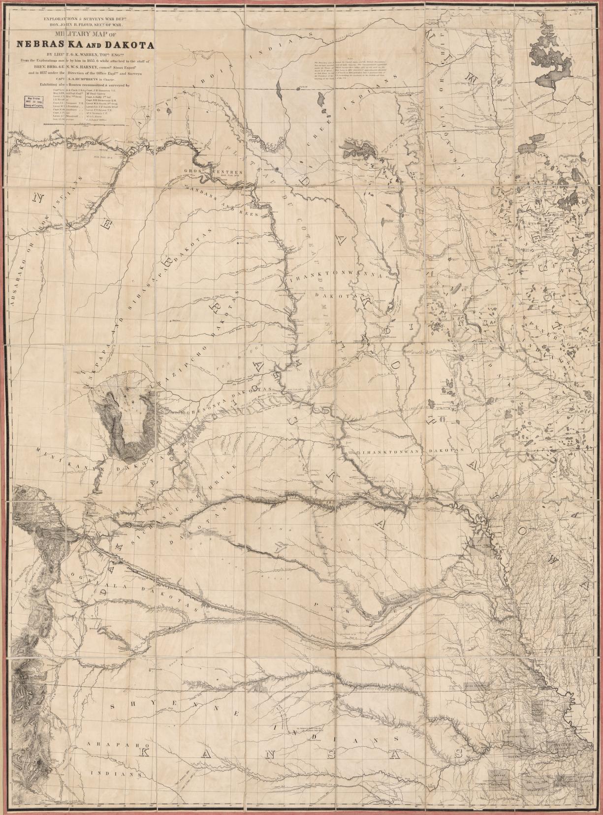
Historic map: Warren, Military Map of Nebraska and Dakota, 1857–58. Lt. G.K. Warren's military reconnaissance of Lakota territory, produced in the years before the 1868 reservation boundary was drawn — the landscape as it existed before the lines were imposed. Library of Congress.
The Taking, 1874–1877
In 1874, Lieutenant Colonel George Armstrong Custer led a military expedition of nearly 1,200 men into the Black Hills in direct violation of the 1868 treaty. His reports confirming gold triggered a rush of illegal settlers. The federal government, rather than enforcing its own treaty obligations, attempted to purchase the Hills. When Lakota leaders refused, the government declared all Lakota who had not reported to reservation agencies by January 31, 1876, to be hostile.
The ensuing Great Sioux War culminated in the Battle of the Little Bighorn in June 1876 — the most significant Lakota military victory of the period, and the last. Congress responded by attaching a rider to the Indian Appropriations Act of 1876 — the "Sell or Starve" rider — cutting off all food rations guaranteed under the 1868 treaty until the Lakota ceded the Black Hills. The Manypenny Commission gathered signatures under these conditions of deliberate starvation, obtaining 230 — ten percent of adult male Lakota, far short of the three-quarters required by Article XII. On February 28, 1877, the United States officially seized approximately seven million acres of the Black Hills. The US Court of Claims would later describe the proceedings as "a more ripe and rank case of dishonorable dealings" likely to be found in no other chapter of American history (Lazarus 1991).

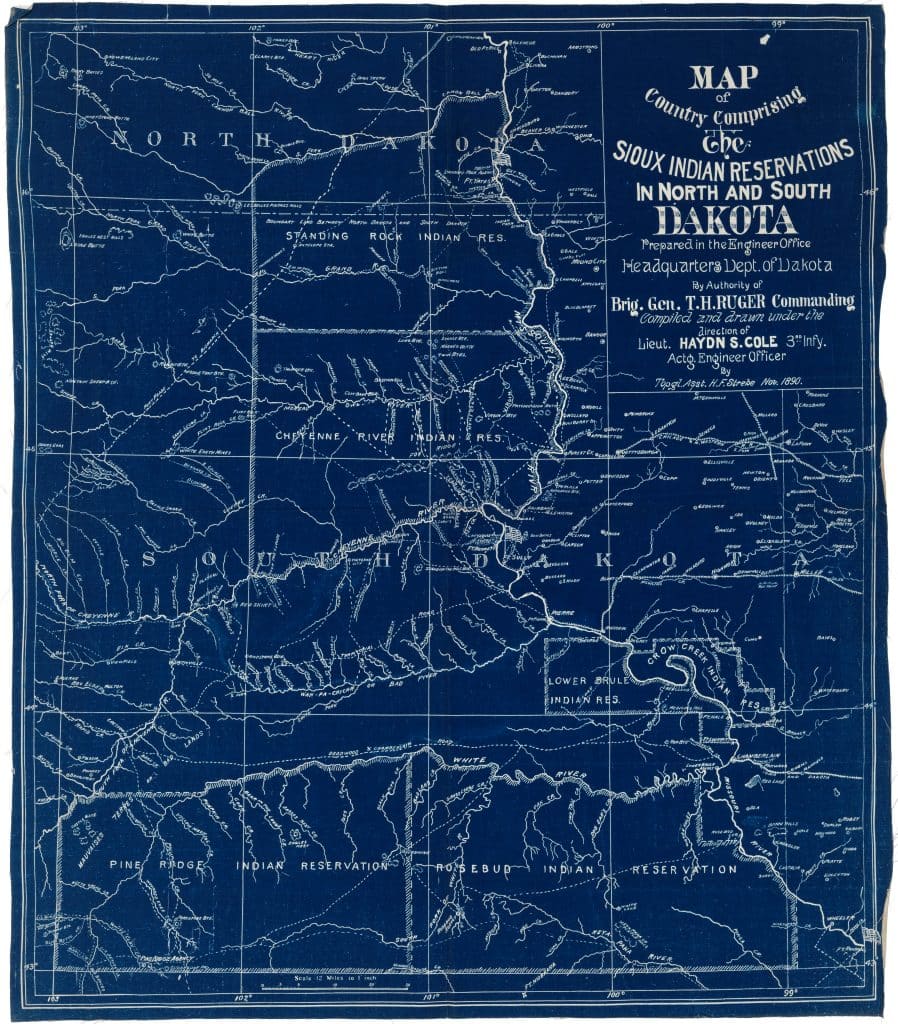
Historic map: Map of Country Comprising the Sioux Indian Reservations in North and South Dakota, November 1890. Prepared by the Engineer Office, Headquarters Dept. of Dakota, by authority of Brig. Gen. T.H. Ruger. Issued weeks before the Wounded Knee massacre — the six fragmented reservations rendered in military engineering blue.
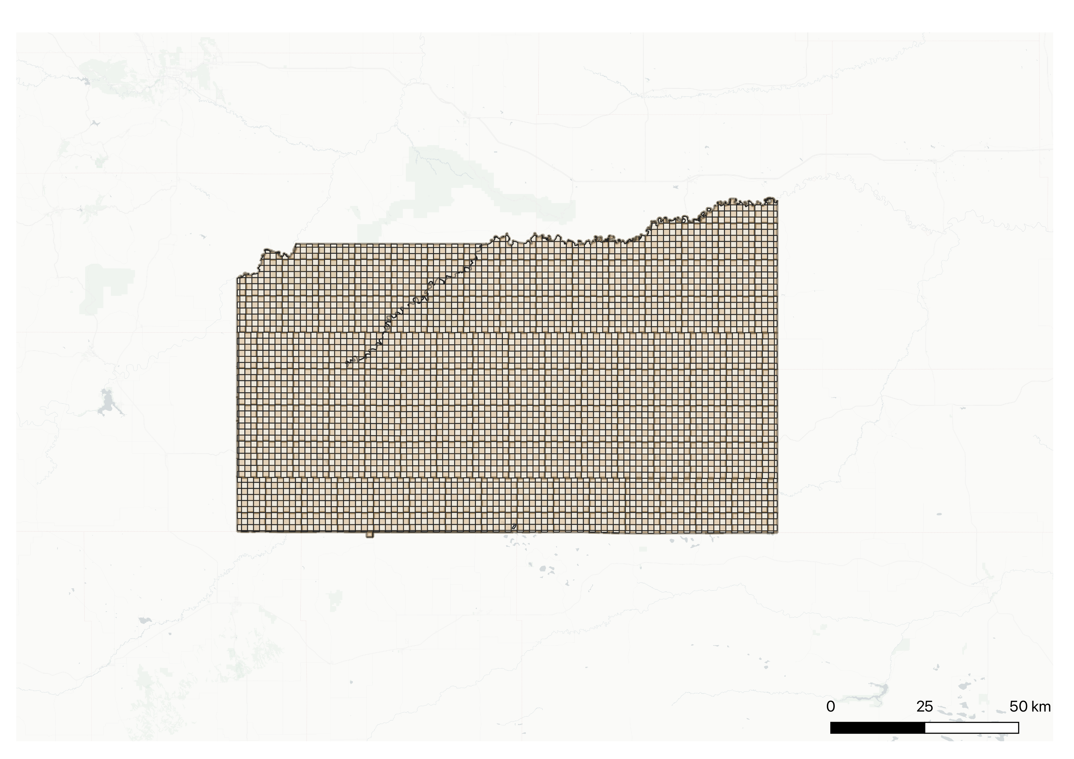
Allotment, 1887–1934
The General Allotment Act of 1887 — the Dawes Act — completed the interior fragmentation of what the 1889 Sioux Act had broken at its external boundaries. Individual Lakota families were assigned 160-acre parcels; land remaining after allotment was declared "surplus" and sold to non-Native settlers. The legal mechanism was individual fee-simple land tenure imposed on a nation whose relationship to land was collective, relational, and non-commodified. Between 1887 and the Indian Reorganization Act of 1934, Native American land holdings nationally collapsed from 138 million acres to 48 million. For the Lakota specifically, allotment cost approximately six million additional acres between 1889 and 1934 (Hoxie 1984). What remained was a checkerboard: trust land interspersed with privately owned and federally administered parcels, the reservation boundary intact but its territorial coherence perforated.
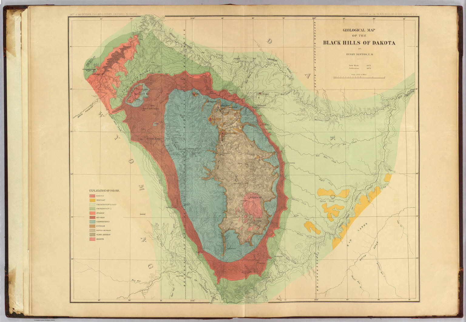
Historic map: Hayden survey / Newton, Geological Map of the Black Hills of Dakota, 1879. Produced under the Dept. of Interior survey; field work conducted 1875 — one year before the U.S. seized the Hills. Mapped gold-bearing strata in territory the United States did not yet legally hold.
Pahá Sápa Today
The twentieth century brought neither resolution nor restoration. The Indian Reorganization Act of 1934 ended allotment but did not return land. The Indian Claims Commission, established in 1946, was designed to adjudicate historical claims through monetary compensation — a structural presumption of the permanence of the taking. After decades of litigation, the Supreme Court ruled unanimously in United States v. Sioux Nation of Indians (1980) that the seizure of the Black Hills was an unconstitutional taking under the Fifth Amendment, awarding $17.1 million in 1877 fair market value plus interest — approximately $102–105 million total.
The Sioux Nations refused it. Acceptance would have legally extinguished their claim to the land itself. The funds, accruing in a BIA trust account, have grown to more than $1.8 billion. They remain unclaimed. As Oglala Sioux Tribal President Frank Star Comes Out has stated: "The Black Hills are not for sale. We will never sell out our holy lands." The Hills remain in federal and state hands, administered as Black Hills National Forest, Mount Rushmore National Memorial, and various private holdings.
Then and Now
Beyond the Map's Horizon
The dispossession documented here did not end with allotment or adjudication. The Pick-Sloan Missouri Basin Program (1944) flooded more than 160,000 acres of Standing Rock and Cheyenne River Sioux reservation land to construct the Oahe Dam — the most fertile bottomland remaining to Lakota communities, sites of dense settlement, gardens, and sheltered wintering grounds. Hundreds of families were displaced without meaningful tribal consent: a bureaucratic dispossession quieter than the treaty era, but no less consequential (Estes 2019).
The American Indian Movement, founded in Minneapolis in 1968, brought Lakota and broader Indigenous claims to renewed national attention. The 71-day occupation of Wounded Knee in 1973 — itself the site of the 1890 massacre of at least 250 Lakota by the 7th Cavalry — reasserted the unresolved legal status of the 1868 Treaty. The standoff did not restore land; it forced the question of whether the United States had ever legitimately held it.
In 2016, the Dakota Access Pipeline reactivated this entire history in concentrated form. The route crossed the Missouri River immediately upstream of the Standing Rock Sioux Reservation, threatening its primary water source and traversing land with unextinguished 1868 treaty claims. The Standing Rock encampment drew water protectors from Indigenous nations across the hemisphere. The Obama administration halted construction in December 2016; the Trump administration reversed the decision weeks later. The pipeline has been operating since 2017; litigation continues. What these maps show as resolved remains, in Lakota legal and political understanding, an open question.
Data Sources
- Royce, Charles C. Indian Land Cessions in the United States (1899), digitized by the Newberry Library
- NHGIS historical boundary data
- Bureau of Indian Affairs land status records
- Native Land Digital
- U.S. Census TIGER/Line shapefiles
- USFS Black Hills National Forest cadastral data
Works Cited
Brown, Dee. Bury My Heart at Wounded Knee: An Indian History of the American West. New York: Holt, Rinehart and Winston, 1970.
Deloria, Vine, Jr., and Raymond J. DeMallie. Documents of American Indian Diplomacy: Treaties, Agreements, and Conventions, 1775–1979. Norman: University of Oklahoma Press, 1999.
Estes, Nick. Our History Is the Future: Standing Rock Versus the Dakota Access Pipeline, and the Long Tradition of Indigenous Resistance. London: Verso, 2019.
Goeman, Mishuana. Mark My Words: Native Women Mapping Our Nations. Minneapolis: University of Minnesota Press, 2013.
Hoxie, Frederick E. A Final Promise: The Campaign to Assimilate the Indians, 1880–1920. Lincoln: University of Nebraska Press, 1984.
Lazarus, Edward. Black Hills, White Justice: The Sioux Nation Versus the United States, 1775 to the Present. New York: HarperCollins, 1991.
Ostler, Jeffrey. The Plains Sioux and U.S. Colonialism from Lewis and Clark to Wounded Knee. Cambridge: Cambridge University Press, 2004.
Royce, Charles C. Indian Land Cessions in the United States. 18th Annual Report of the Bureau of American Ethnology. Washington, DC: Government Printing Office, 1899.
United States v. Sioux Nation of Indians, 448 U.S. 371 (1980).